
Autonomous systems are increasingly expected to operate in warehouses, tunnels, forests, urban canyons, disaster sites, underwater environments, and contested areas where satellite navigation is unreliable or completely unavailable. In these conditions, GPS-denied navigation becomes a core capability rather than an optional feature. The most dependable solutions usually combine multiple sensors, such as cameras, LiDAR, radar, inertial measurement units, wheel encoders, barometers, magnetometers, and known maps, using robust estimation algorithms that can continue to provide position, velocity, and attitude when GNSS signals disappear.
TLDR: The strongest open source GPS-denied navigation approaches are based on visual inertial odometry, LiDAR inertial odometry, SLAM, and sensor fusion filters. Projects such as ORB SLAM3, VINS Fusion, OpenVINS, LIO SAM, FAST LIO2, Cartographer, RTAB Map, and robot localization are widely used foundations for autonomous robots, drones, and vehicles. The best choice depends on sensor payload, compute budget, environment texture, lighting, geometry, and safety requirements.
Why GPS-Denied Navigation Is Hard
GPS-denied navigation is difficult because autonomous systems must estimate their own motion without an external global reference. Small errors in acceleration, rotation, feature tracking, or scan matching can accumulate over time, creating drift. If the robot cannot detect and correct that drift, its map, trajectory, and mission decisions may become unreliable.
Effective navigation stacks therefore need more than a single algorithm. They need state estimation, mapping, loop closure, outlier rejection, time synchronization, and health monitoring. Open source projects are valuable because they allow engineering teams to inspect assumptions, reproduce results, integrate custom sensors, and validate performance under operational conditions.
1. Visual Inertial Odometry: ORB SLAM3, VINS Fusion, and OpenVINS
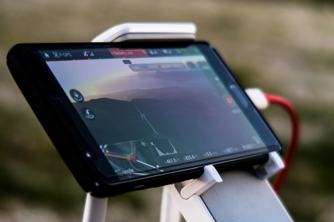
Visual inertial odometry, often abbreviated as VIO, estimates motion by combining camera observations with inertial measurements. Cameras provide rich environmental information, while IMUs provide high rate motion data. Together, they can deliver accurate short to medium range localization without GPS.
ORB SLAM3 is one of the best known open source SLAM systems. It supports monocular, stereo, RGB D, and visual inertial configurations. Its strength is a complete SLAM pipeline that includes tracking, local mapping, loop closing, and map reuse. For autonomous systems that need to recognize previously visited areas and reduce accumulated drift, ORB SLAM3 is a serious candidate.
VINS Fusion is another respected option, especially for drone and mobile robotics applications. It supports monocular camera plus IMU, stereo camera plus IMU, and GPS fusion when available. In GPS-denied operation, the visual inertial pipeline can continue estimating motion, while loop closure helps reduce drift when the system revisits known places.
OpenVINS is a research grade open source framework focused on visual inertial estimation. It is particularly useful for teams that need transparency, clear mathematical foundations, and extensibility. OpenVINS is often attractive for academic, defense, aerospace, and industrial teams that want to study estimator behavior rather than treat navigation as a black box.
- Best suited for: drones, indoor robots, wearable systems, inspection platforms, and lightweight autonomous vehicles.
- Strengths: low sensor cost, compact payload, strong performance in textured environments.
- Limitations: degraded performance in darkness, glare, fog, dust, blank walls, rapid motion blur, or repetitive visual patterns.
2. LiDAR Inertial Odometry: LIO SAM and FAST LIO2
LiDAR inertial odometry, or LIO, combines 3D laser scans with IMU data. It is highly valuable for autonomous ground robots, vehicles, and larger drones because LiDAR directly measures geometry. Unlike cameras, LiDAR does not depend on ambient lighting, making it more reliable in dark tunnels, night operations, warehouses, and underground facilities.
LIO SAM is a widely used open source package that couples LiDAR odometry, IMU preintegration, factor graph optimization, and loop closure. Built around graph based estimation, it can produce accurate trajectories and maps when properly configured. It is often used with ROS and has become a practical reference framework for LiDAR based navigation research and prototyping.
FAST LIO2 is designed for efficient and accurate LiDAR inertial odometry. It is known for real time operation and direct registration methods that can work well with modern solid state and spinning LiDAR sensors. For platforms with limited compute resources but demanding update rates, FAST LIO2 is a strong option to evaluate.
- Best suited for: autonomous vehicles, underground robots, warehouse robots, mining systems, and inspection platforms.
- Strengths: robust geometric perception, strong performance without lighting, good map quality.
- Limitations: higher sensor cost, performance challenges in feature poor open spaces, possible degradation in rain, snow, smoke, or dust.
3. Graph Based SLAM: Google Cartographer and GTSAM Based Systems
SLAM, or simultaneous localization and mapping, allows a robot to build a map while estimating its location inside that map. Many modern SLAM systems use factor graphs, where poses, landmarks, IMU constraints, loop closures, and sensor measurements are represented as connected factors. This structure supports powerful optimization and is well suited for correcting drift over time.
Google Cartographer is an open source SLAM system that supports 2D and 3D mapping with LiDAR and IMU data. It has been used extensively in robotics research and commercial prototyping. Cartographer’s strength is its mature scan matching and submap based design, which makes it useful for indoor mapping, mobile robots, and structured environments.
GTSAM, the Georgia Tech Smoothing and Mapping library, is not a full navigation stack by itself. Instead, it is a powerful optimization library used to build factor graph based estimation systems. Many advanced SLAM and odometry projects rely on GTSAM or similar concepts to fuse IMU, LiDAR, camera, wheel odometry, and loop closure constraints.
Graph based methods are especially important in GPS-denied environments because they offer a principled way to reduce accumulated error. When a system recognizes that it has returned to a previous location, a loop closure constraint can be added to the graph, improving the entire trajectory estimate rather than only the current pose.
4. RGB D and Multi Sensor SLAM: RTAB Map
RTAB Map is a practical open source solution for appearance based loop closure and multi sensor SLAM. It supports RGB D cameras, stereo cameras, LiDAR, visual odometry, wheel odometry, and IMU integration. This flexibility makes it popular for research robots and indoor autonomous platforms.
RTAB Map is particularly useful when a robot must build a map of an indoor space and later localize within it. It can manage large maps, detect loop closures, and integrate with ROS based navigation stacks. For teams building service robots, inspection robots, or laboratory platforms, RTAB Map provides a relatively accessible path to GPS-denied mapping and localization.
- Best suited for: indoor mobile robots, research platforms, service robots, and mapping applications.
- Strengths: flexible sensor support, strong loop closure capabilities, practical ROS integration.
- Limitations: performance depends heavily on sensor quality, lighting, compute resources, and environment structure.
5. Probabilistic Sensor Fusion: robot localization, EKF, and UKF
Not every GPS-denied navigation problem requires full SLAM. In many systems, the essential requirement is to fuse available motion sources into a reliable state estimate. This is where Extended Kalman Filters, Unscented Kalman Filters, and related Bayesian estimators remain highly relevant.
The ROS package robot localization is a widely used open source framework for fusing data from wheel encoders, IMUs, visual odometry, LiDAR odometry, and other pose or velocity sources. It provides EKF and UKF implementations and is commonly used as the state estimation layer in mobile robot stacks.
For example, a ground robot may use wheel odometry for short term motion, an IMU for orientation and angular velocity, and LiDAR odometry for drift correction. A filter can combine these streams into a smoother and more resilient estimate. While this does not eliminate drift by itself, it improves consistency and provides a common state output for planning and control.
6. Radar Odometry and Emerging Open Source Options
Radar based localization is gaining attention because radar can operate in darkness, dust, fog, smoke, rain, and other visually degraded conditions. Compared with LiDAR and cameras, radar measurements are noisier and lower resolution, but they can be extremely valuable for rugged autonomous systems.
Open source radar odometry and radar SLAM projects are less standardized than visual and LiDAR alternatives, but the field is developing quickly. Algorithms often rely on scan matching, Doppler velocity estimation, feature extraction, and fusion with IMU data. Radar is especially relevant for autonomous vehicles, field robots, and defense oriented systems that must operate in degraded visual environments.
Teams considering radar should expect more integration work than with mature VIO or LIO packages. Calibration, radar mounting, interference handling, and environment specific validation are critical. However, radar can provide resilience that camera only or LiDAR only systems may not achieve under adverse conditions.
How to Choose the Right Algorithm
The best open source GPS-denied navigation algorithm depends on the operating environment and mission risk. A small indoor drone may favor OpenVINS or VINS Fusion because cameras and IMUs are lightweight. A warehouse robot may benefit from RTAB Map, Cartographer, or robot localization combined with wheel odometry. A field robot or autonomous vehicle may require LIO SAM or FAST LIO2 to exploit 3D structure.
Selection should be based on measurable criteria rather than popularity alone. Important evaluation factors include:
- Drift rate: How quickly does position and orientation error grow without loop closure?
- Failure modes: What happens in darkness, dust, repetitive corridors, open fields, or fast motion?
- Compute load: Can the algorithm run in real time on the target hardware?
- Sensor calibration: How sensitive is the system to camera intrinsics, LiDAR to IMU alignment, and timing offsets?
- Map requirements: Does the robot need online mapping, prior map localization, or both?
- Operational assurance: Can the system detect degraded estimates and trigger safe behavior?
Practical Deployment Considerations
Open source software is a foundation, not a complete safety case. Production autonomous systems require careful calibration, dataset testing, environmental validation, redundancy, and monitoring. Time synchronization is particularly important. Even a strong VIO or LIO algorithm can fail if camera frames, IMU samples, and LiDAR scans are misaligned by a few milliseconds.
Engineers should also evaluate degraded operation. A trustworthy system should not merely produce a pose estimate; it should provide signals that indicate confidence, covariance, tracking quality, feature count, scan matching score, or innovation residuals. These indicators allow higher level autonomy software to slow down, stop, reinitialize, or switch modes when localization becomes unreliable.
Conclusion
The leading open source GPS-denied navigation algorithms fall into several dependable families: visual inertial odometry, LiDAR inertial odometry, graph based SLAM, RGB D and multi sensor SLAM, and probabilistic sensor fusion. Projects such as ORB SLAM3, VINS Fusion, OpenVINS, LIO SAM, FAST LIO2, Cartographer, RTAB Map, GTSAM, and robot localization represent some of the most credible starting points.
For serious autonomous systems, the most robust answer is rarely a single algorithm. It is a carefully engineered navigation architecture that combines complementary sensors, validates estimates continuously, corrects drift when possible, and fails safely when confidence deteriorates. Open source tools make that architecture more transparent, auditable, and adaptable, which is exactly what GPS-denied autonomy demands.